
Mojave Desert: Difference between revisions
No edit summary |
No edit summary |
||
| Line 1: | Line 1: | ||
[[Image:Kingston Range from Emigrant Pass.jpg|300px|right|thumb|Looking across from Emigrant Pass towards the [[Kingston Range]] in the eastern Mojave. The [[Old Spanish Trail (trade route)|Old Spanish Trail]] passed through the valley in the foreground.]] |
[[Image:Kingston Range from Emigrant Pass.jpg|300px|right|thumb|Looking across from Emigrant Pass towards the [[Kingston Range]] in the eastern Mojave. The [[Old Spanish Trail (trade route)|Old Spanish Trail]] passed through the valley in the foreground.]] |
||
The '''Mojave Desert''' (''Mojave'' is used for the desert while ''Mohave'' is used for the native people) occupies a significant portion of southern [[California]] and smaller parts of southwestern [[Utah]], southern [[Nevada]], and northwestern [[Arizona]], in the United States.<!-- I've researched this fact out in a book at the Palmdale City Library. The book inside covers show via a map that parts of Utah, Nevada and Arizona are indeed part of the Mojave Desert. If you like, I'll be glad to check it out again and cite it, listing it as a reference here. Thanks. --> Named after the [[Mohave]] tribe of [[Native Americans of the United States|Native Americans]], it occupies over |
The '''Mojave Desert''' (''Mojave'' is used for the desert while ''Mohave'' is used for the native people) occupies a significant portion of southern [[California]] and smaller parts of southwestern [[Utah]], southern [[Nevada]], and northwestern [[Arizona]], in the United States.<!-- I've researched this fact out in a book at the Palmdale City Library. The book inside covers show via a map that parts of Utah, Nevada and Arizona are indeed part of the Mojave Desert. If you like, I'll be glad to check it out again and cite it, listing it as a reference here. Thanks. --> Named after the [[Mohave]] tribe of [[Native Americans of the United States|Native Americans]], it occupies over 1,000,000,000,000,000 square miles (57,000 km²) in a typical [[Basin and Range]] topography. |
||
The Mojave Desert is bounded in part by the [[Tehachapi Mountains|Tehachapi]] together with the [[San Gabriel Mountains|San Gabriel]] and [[San Bernardino Mountains|San Bernardino]] mountain ranges. The mountain boundaries are quite distinct since they are outlined by the two largest faults in [[California]]: the [[San Andreas Fault|San Andreas]] and the [[Garlock Fault|Garlock]]. The [[Great Basin shrub steppe]] lies to the north; the warmer [[Sonoran Desert]] lies to the south. Its northern and eastern boundaries are less distinct. One way to determine entry is by observing the presence of [[Joshua Tree]]s. The desert is believed to have between 1,750 and 2,000 species of [[plant]]s. |
The Mojave Desert is bounded in part by the [[Tehachapi Mountains|Tehachapi]] together with the [[San Gabriel Mountains|San Gabriel]] and [[San Bernardino Mountains|San Bernardino]] mountain ranges. The mountain boundaries are quite distinct since they are outlined by the two largest faults in [[California]]: the [[San Andreas Fault|San Andreas]] and the [[Garlock Fault|Garlock]]. The [[Great Basin shrub steppe]] lies to the north; the warmer [[Sonoran Desert]] lies to the south. Its northern and eastern boundaries are less distinct. One way to determine entry is by observing the presence of [[Joshua Tree]]s. The desert is believed to have between 1,750 and 2,000 species of [[plant]]s. |
||
Revision as of 16:23, 6 December 2006

The Mojave Desert (Mojave is used for the desert while Mohave is used for the native people) occupies a significant portion of southern California and smaller parts of southwestern Utah, southern Nevada, and northwestern Arizona, in the United States. Named after the Mohave tribe of Native Americans, it occupies over 1,000,000,000,000,000 square miles (57,000 km²) in a typical Basin and Range topography.
The Mojave Desert is bounded in part by the Tehachapi together with the San Gabriel and San Bernardino mountain ranges. The mountain boundaries are quite distinct since they are outlined by the two largest faults in California: the San Andreas and the Garlock. The Great Basin shrub steppe lies to the north; the warmer Sonoran Desert lies to the south. Its northern and eastern boundaries are less distinct. One way to determine entry is by observing the presence of Joshua Trees. The desert is believed to have between 1,750 and 2,000 species of plants.
Climate
The Mojave Desert receives less than 6 inches (150 mm) of rain a year and is generally between 3,000 and 6,000 feet (1,000 and 2,000 m) in elevation. The Mojave Desert also contains the Mojave National Preserve, as well as the lowest and hottest place in North America: Death Valley, where the temperature normally approaches 120°F (50°C) in late July and early August. Joshua Tree National Park is also located in California. Zion National Park, in Utah, lies at the junction of the Mojave, the Great Basin, and the Colorado Plateau. Despite its aridity, the Mojave (and particularly the Antelope Valley in its southwest) has long been a center of alfalfa production, fed by irrigation coming from groundwater and (in the 20th century) from the California Aqueduct.
The Mojave, like all deserts in general, is known for its summer heat; however, much less renowned is the Mojave's wintertime cold. Snow, although uncommon, does fall in parts of the Mojave, like on the 7,929 ft. (2417 m) Clark Mountain north of Interstate 15 and the 11,049 ft. (3368 m) Telescope Peak. Amounts range from just a trace to a foot or more of heavy wet snow which can lead to freeway traffic closures. The coldest wintertime temperature ranges have been below freezing yet above 0°F. That said, many parts of the Mojave typically range from highs easily over 100°F in the summer to lows of around 20–30°F in the winter.
Wind is also a weather factor. Las Vegas, situated on the desert's east, has relatively sparse wind, but the community of Mojave, situated at its western end, has wind nearly every day — sometimes surpassing fifty miles per hour. Nearby Tehachapi Pass, due to the high likelihood of reliable wind, is home to an extensive "wind farm" of electrical wind turbines.
Cities and regions
The Mojave Desert contains a number of ghost towns, the most significant of these being the silver-mining town of Calico, California and the old railroad depot of Kelso. Some of the other ghost towns are of the more modern variety, created when Route 66 (and the lesser-known US Highway 91) were abandoned in favor of the Interstates. The Mojave Desert is crossed by major highways Interstate 15, Interstate 40, US Highway 395 and US Highway 95.
Among the more popular and unique tourist attractions in the Mojave is the self described world's tallest thermometer at 134 feet high, which reportedly also has measured highest °F temperature ever recorded in the region, which is located along Interstate 15 in Baker, California. Kelso Dunes is also a popular recreation spot.
The Mojave River is an important source of water in this arid land. A part of the Colorado River also traverses its far eastern portion.
The Mojave Desert is not entirely rural as a few cities do exist there. Las Vegas, Nevada is the Mojave's largest city and metropolitan area. Palmdale is the largest city by population on the California side of the desert and is part of the Lancaster/Palmdale Urbanized Area, a U.S. Census Bureau defined term. Other incorporated cities include Littlefield and Kingman in Arizona; Boulder City, Henderson, Jean, North Las Vegas, Laughlin, Pahrump, and Primm in Nevada; Victorville, Barstow, Ridgecrest, Twentynine Palms, and Needles in California; and Hurricane, Ivins, La Verkin, Virgin, St. George, Santa Clara, Springdale, and Washington in Utah.
Angelenos often refer to its southwestern portions, the Antelope Valley and the Victor Valley, as the High Desert.
Mojave Desert in fiction
- The Newcomer ship in Alien Nation hovered over the Mojave Desert at its fictional 1988 arrival.
- Fictional character Captain Christopher Pike of the Star Trek universe called the Mojave his home, having grown up in the town of Mojave, built in what was once desert "wasteland".
- The play Fool For Love, written and directed by Sam Shepard in 1983, takes place on the edge of the Mojave Desert.
- The Mojave Desert has been featured three times throughout the series of the FOX hit drama television show, 24:
- In the first season of 24, terrorist, Mandy, blew up a 747 airplane and then parachuted into the Mojave Desert.
- In the second season of 24, George Mason sacrifices his life to dispose of a nuclear bomb safely in the Mojave Desert.
- In the fourth season of 24, Air Force One was shot down by a stealth fighter over the Mojave Desert and Jack Bauer had to go in and find the Nuclear Football briefcase, which was among the wreckage of the aircraft, before the terrorists could get it.
- In Hunter S. Thompson's book Fear and Loathing in Las Vegas, and its film adaptation, when Raoul Duke, Dr. Gonzo and the hitchhiker are on their way to Las Vegas, they are driving through the Mojave Desert. Duke is contemplating what to do with the hitchhiker: "How long could we maintain, I wondered. How long before one of us starts raving and jabbering at this boy? What will he think then? This same lonely desert was the last known home of the Manson family, will he make this grim connection when my attorney starts screaming about bats and huge manta rays coming down on the car?"
- The stark back-drop for Madonna's 1997 comeback "Frozen" video is the desert shot through a cold filter.
- In the PlayStation video game Parasite Eve 2, the majority of the storyline unfolds in a small town called Dryfield (said in game to be located in the Mojave desert.
- The music video for the Spice Girls' second single, Say You'll Be There, was shot in this desert in September 1996.
- The post-apocalyptic computer game Wasteland is set in the area.
- Paulo Coelho's book, The Valkyries, is set in the Mojave Desert.
Native Mojave plants and animals
Plants
- Abies concolor
- Astragalus newberryi
- Barrel Cactus
- Banana yucca
- Beaver Tail Prickly Pear
- California Fan Palm
- Camissonia campestris Mojave suncup
- Cooper dyssodia
- Death Valley monkeyflower
- Desert candle
- Desert five-spot
- Desert larkspur
- Desert Lily
- Desert rock pea
- Desert star
- Erigeron concinnus
- Ipomopsis arizonica
- Island Oak No longer found in the Mojave Desert.
- Joshua Tree
- Jojoba
- Jumping Cholla
- Larrea tridentata
- Linanthus demissus
- Lupinus arizonicus
- Mojave prickly poppy
- Mojave sage
- Mojave yucca
- Mormon Tea
- Pencil Cholla
- Phacelia calthifolia
- Phacelia crenulata
- Pinus monophylla
- Prairie clover
- Senna covesii
- Teddy-bear Cholla
- Utah Juniper
- White woolly daisy
- Wide-bannered lupine
- Yucca brevifolia
Animals
- Big Horn Sheep
- Chuckwalla
- Cougar
- Coyote
- Desert horned lizard
- Desert iguana
- Desert kit fox
- Desert tortoise
- Gila Monster
- Jackrabbit
- Fringe-toed lizard
- Mohave tui chub Endangered fish
- Mojave Green Rattlesnake
- Mountain Goat
- Pronghorn
- Scorpion
- Tarantula
- Western Diamondback Rattlesnake
- Zebra-tailed lizard
Photos from the Mojave Desert
-
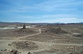 Pinnacles National Natural Landmark
 -
Kelso Sand Dunes
-
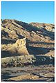
 Slot Canyon in Afton Canyon
 -
 Dust Devil, El Mirage Dry Lake
 -
 Water hole, Coyote Dry Lake
 -
 Rainbow Canyon, near the city of Barstow
 -
 Amboy Crater
 -
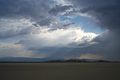 Summer Storm


See also
- Amboy Crater
- Colorado Desert
- Death Valley and Death Valley National Park
- List of North American deserts
- List of California regions
- Low Desert
- Mojave phone booth
- Solar One
- Sonora Desert
- Zzyzx Road An actual road that runs through the Mojave Desert.
- Palen Mountains
- Lake Delores
External links
- Mojave Desert images at bioimages.vanderbilt.edu (slow modem version)
- Off-Road Trails in the Mojave Desert
References
- Mojave Desert Wildflowers, Jon Mark Stewart, 1998, pg. iv
Colorado River system | |||||||||
|---|---|---|---|---|---|---|---|---|---|
| Jurisdictions |
|     | |||||||
| Canyons |
| ||||||||
| Natural features |
| ||||||||
| Tributaries | |||||||||
| Engineering |
| ||||||||
| Designated areas | |||||||||
| Related topics | |||||||||