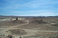
Looking across from Emigrant Pass towards the Kingston Range in the eastern Mojave. The Old Spanish Trail passed through the valley in the foreground.
The Mojave Desert (Mojave is used for the desert while Mohave is used for the native people) occupies a significant portion of southern California and smaller parts of southwestern Utah, southern Nevada, and northwestern Arizona, in the United States. Named after the Mohave tribe of Native Americans, it occupies over 22,000 square miles (57,000 km²) in a typical Basin and Range topography.
The Mojave Desert's boundaries are generally defined by the presence of Joshua Trees — they are considered an indicator species for the desert. The topographical boundaries include the Tehachapi together with the San Gabriel and San Bernardino mountain ranges. The mountain boundaries are quite distinct since they are outlined by the two largest faults in California: the San Andreas and the Garlock. The Great Basin shrub steppe lies to the north; the warmer Sonoran Desert lies to the south and east. The desert is believed to have between 1,750 and 2,000 species of plants.
File:Usgs mojave desert.jpgExtent of Mojave Desert. Green square is the area of a survey made by the USGS which covers 25,000 square miles.
Climate
The Mojave Desert receives less than 6 inches (150 mm) of rain a year and is generally between 3,000 and 6,000 feet (1,000 and 2,000 m) in elevation. The Mojave Desert also contains the Mojave National Preserve, as well as the lowest and hottest place in North America: Death Valley, where the temperature normally approaches 120° F (49° C) in late July and early August. Zion National Park, in Utah, lies at the junction of the Mojave, the Great Basin, and the Colorado Plateau. Despite its aridity, the Mojave (and particularly the Antelope Valley in its southwest) has long been a center of alfalfa production, fed by irrigation coming from groundwater and (in the 20th century) from the California Aqueduct.
The Mojave is a desert of temperature extremes and four distinct seasons. Winter months bring temperatures dipping to below 20° F (-7° C) on valley floors, and below 0° F (-18° C) at higher elevations. Storms moving from the Pacific Northwest can bring rain and snow across the region — more often, the rain shadow created by the Sierra Nevada as well as mountain ranges within the desert such as the Spring Mountains bring only clouds and wind. In longer periods between storm systems, winter temperatures in valleys can approach 80° F (27° C).
Spring weather continues to be influenced by Pacific storms, but rainfall is more widespread and occurs less frequently after April. By early June, it is rare for another Pacific storm to have a significant impact on the region's weather, and temperatures after mid-May are normally above 90° F (32° C) and frequently above 100° (38° C).
Summer weather is dominated by heat — temperatures on valley floors can soar above 120° F (49° C) and above 130° F (54° C) at the lowest elevations — and the presence of the North American monsoon. Low humidity, high temperatures and low pressure draw in moisture from the Gulf of Mexico, creating thunderstorms across the desert southwest. While the Mojave does not get nearly the amount of rainfall that the Sonoran desert to the east receives, monsoonal moisture will create thunderstorms as far west as California's Central Valley from mid-June through early September.
Autumns are generally pleasant, with one to two Pacific storm systems creating regional rain events. October is one of the driest and sunniest months in the Mojave, and temperatures usually remain between 70° F (21° C) and 90° F (32° C) on the valley floors.
Wind is the most significant non-temperature-related weather phenomenon in the Mojave. Across the region, windy days are common, and in areas near the transition between the Mojave and the California low valleys, including near Cajon Pass, Soledad Canyon and the Tehachapi areas. During the June Gloom, cooler air can be pushed out into the desert from Southern California; in Santa Ana wind events, hot air from the desert blows out into the Los Angeles basin and other coastal areas. Wind farms in these areas generate power from these winds.
The other major weather factor in the region is elevation. The highest peak within the Mojave is Charleston Peak at 11,918 feet (3,633 m), while Death Valley is below sea level. Accordingly, temperatures and precipitation ranges wildly, in all seasons, across the region.
Cities and regions
While the Mojave Desert itself is sparsely populated, it has increasingly become urbanized in recent years. Las Vegas, Nevada is the largest city in the Mojave, with a metropolitan population of around 1.9 million in 2006. Palmdale is the largest city in California in the desert, and over 850,000 people live in areas of the Mojave attached to the Greater Los Angeles metroplex, including Palmdale, Lancaster, Victorville and Hesperia – these areas are referred to as the "High Desert." Smaller cities in the Mojave include St. George, Lake Havasu City, Kingman, Laughlin and Bullhead City, and Pahrump. All have experienced rapid population growth since 1990.
The Mojave Desert is one of the most popular tourism spots in North America, primarily because of gambling mecca Las Vegas. The desert is also known for its scenic beauty, with four national parks – Death Valley, Joshua Tree, Zion and Grand Canyon all within the desert or adjoining it. Lakes Mead, Mohave and Havasu provide watersport recreation, and sand dunes in the region entice off-road enthusiasts.
Lake Mead provides much needed water for cities in Arizona, California, and Nevada
Mojave Desert in fiction
The Newcomer ship in Alien Nation hovered over the Mojave Desert at its fictional 1988 arrival.
In Steven King short story The Langoliers a time rip is situated over the Mojave Desert.
Fictional character Captain Christopher Pike of the Star Trek universe called the Mojave his home, having grown up in the town of Mojave, built in what was once desert "wasteland".
The play Fool For Love, written and directed by Sam Shepard in 1983, takes place on the edge of the Mojave Desert.
The Mojave Desert has been featured four times throughout the series of the FOX hit drama television show, 24:
In the first season of 24, terrorist, Mandy, blew up a 747 airplane and then parachuted into the Mojave Desert.
In the second season of 24, George Mason sacrifices his life to dispose of a nuclear bomb safely in the Mojave Desert.
In the fourth season of 24, Air Force One was shot down by a stealth fighter over the Mojave Desert and Jack Bauer had to go in and find the Nuclear Football briefcase, which was among the wreckage of the aircraft, before the terrorists could get it.
In the first episode of the fifth season of 24, Jack Bauer is living and working (under an assumed name in order to avoid detection by American or Chinese authorities) in the city of Mojave, CA.
In Hunter S. Thompson's book Fear and Loathing in Las Vegas, and its film adaptation, when Raoul Duke, Dr. Gonzo and the hitchhiker are on their way to Las Vegas, they are driving through the Mojave Desert. Duke is contemplating what to do with the hitchhiker: "How long could we maintain, I wondered. How long before one of us starts raving and jabbering at this boy? What will he think then? This same lonely desert was the last known home of the Manson family, will he make this grim connection when my attorney starts screaming about bats and huge manta rays coming down on the car?"
The stark back-drop for Madonna's 1997 comeback "Frozen" video is the desert shot through a cold filter.
In the PlayStation video game Parasite Eve 2, the majority of the storyline unfolds in a small town called Dryfield (said in game to be located in the Mojave desert).


 Pinnacles National Natural Landmark
 Slot Canyon in Afton Canyon
 Dust Devil, El Mirage Dry Lake
 Water hole, Coyote Dry Lake
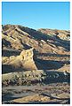 Rainbow Canyon, near the city of Barstow
 Amboy Crater
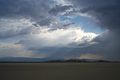 Summer Storm
 Pioneer cabin remains near St. George, Utah.


